-
 Forecasters say hot weather from a heat dome hitting California won’t reach the Willamette Valley or Oregon Coast.
 -
 There’s a chance that residents on the central coast and the Willamette Valley will see snow in the lower elevations this week. But forecasters aren’t sure of the exact location.
 -
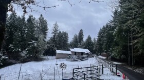
 Weather forecasters say snow could fall in Eugene or Portland this week.
 -
Weather forecasters expect days of snowstorms beginning Monday evening to hit mountain passes in southern Washington and north-central Oregon.
-
 Scientists say it’s unlikely Oregon’s record low snowpack will recover before the end of winter.
 -
 The state is experiencing a historically low snowpack, but a likely shift in the weather could bring some snow to Oregon's mountains.
 -
 Heavy snow Tuesday through Thursday could lead to treacherous travel conditions in the Cascades and some areas of Eastern Oregon. Officials advise people to delay travel if possible.
 -
 Forecasters with the National Weather Service are closely monitoring the windstorm but say it’s still too early to predict how strong those winds will be on Wednesday.
 -
 Coastal areas are still responding to landslides caused by last week’s precipitation could see up to 5 inches of rain through Friday.
 -
 Triple-digit temps are expected along both sides of the Oregon Cascades, and stretching east to the John Day Basin and Blue Mountains.
 -
 As much of Oregon endures consecutive days of high heat, climate data shows the state has seen more 90 degree Fahrenheit or hotter days over the past 10 years than in the decades that came before.
 -
 The National Weather Service is suspending some weather balloon launches because of staffing shortages.


Play Live Radio
Next Up:
0:00
0:00
Available On Air Stations


