-
A winter storm warning has been issued for the Oregon Cascades from Tuesday evening through early Thursday morning.
-
 The National Weather Service says there is elevated fire risk this week for Bend, Madras, Prineville, Redmond and other communities in central Oregon.
 -
 Forecasters say hot weather from a heat dome hitting California won’t reach the Willamette Valley or Oregon Coast.
 -
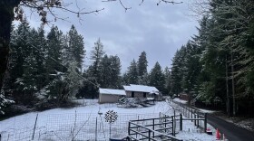 There’s a chance that residents on the central coast and the Willamette Valley will see snow in the lower elevations this week. But forecasters aren’t sure of the exact location.
 -
 Weather forecasters say snow could fall in Eugene or Portland this week.
 -
The Willamette Valley has been stuck in a dry, cold weather pattern for a long time, and other than the chance for a weak respite late this week, the high pressure will continue until at least Tuesday into Wednesday, according to the National Weather Service.
-
 Heavy snow Tuesday through Thursday could lead to treacherous travel conditions in the Cascades and some areas of Eastern Oregon. Officials advise people to delay travel if possible.
 -
 Forecasters with the National Weather Service are closely monitoring the windstorm but say it’s still too early to predict how strong those winds will be on Wednesday.
 -
 Most parts of Oregon avoided serious flooding as a result of Thursday's atmospheric river. A new round of snow is headed for the Cascades.
 -
 Coastal areas are still responding to landslides caused by last week’s precipitation could see up to 5 inches of rain through Friday.
 -
 The National Weather Service warns of significant rainfall for the Willamette Valley and the Oregon Coast as two atmospheric rivers bring flood risks, landslides, and hazardous travel.
 -
 Virtually every part of Oregon has one or more National Weather Service notices set for this weekend.


Play Live Radio
Next Up:
0:00
0:00
Available On Air Stations


